Climbing Pikes Peak (14,115‘) is a big day no matter which trail you take. Most people do the classic Barr Trail route from Manitou Springs (about 26 miles roundtrip), or the shorter Crags route from Divide (about 13 miles).
I’ve done it both ways (once on Barr and six times via the Crags), and also hiked it from Gillet on the old Gillet Trail (shorter than Barr Trail and less steep than the Crags route). In 2006, as part of the Zebulon Pike Bicentennial Climb, I did it over three days and 26 miles one way, starting in southeast Colorado Springs and climbing over several other mountains along the way, presumably following Pike’s 1806 path.
If you want to skip the long hike up America’s Mountain, you can drive to the top on the paved Pikes Peak Highway. The new summit house is open, complete with gift shop, cafe, and exhibits, and the wraparound viewing decks are complete. All you need from late-May through the end of September is a permit. A few miles up the road, you’ll hit the entrance station, where you have to pay another $15 per adult, less for kids.
Last week, I decided to take the easy route up Pikes Peak. I drove. To make the most of my day (and my money), I added a few easy hikes to the trip: four unranked summits off the highway on the west side of the peak. I’d done two of them before, but two others were new to me. I’d discovered them in Stewart M. Green’s book Climbing Pikes Peak: A Hiker’s Guide to the Peak.
I’ll give you a summary of the directions. If you want more details, pick up the book. It has other hikes including more summit hikes too, plus a bunch of route descriptions to the top of Pikes Peak.
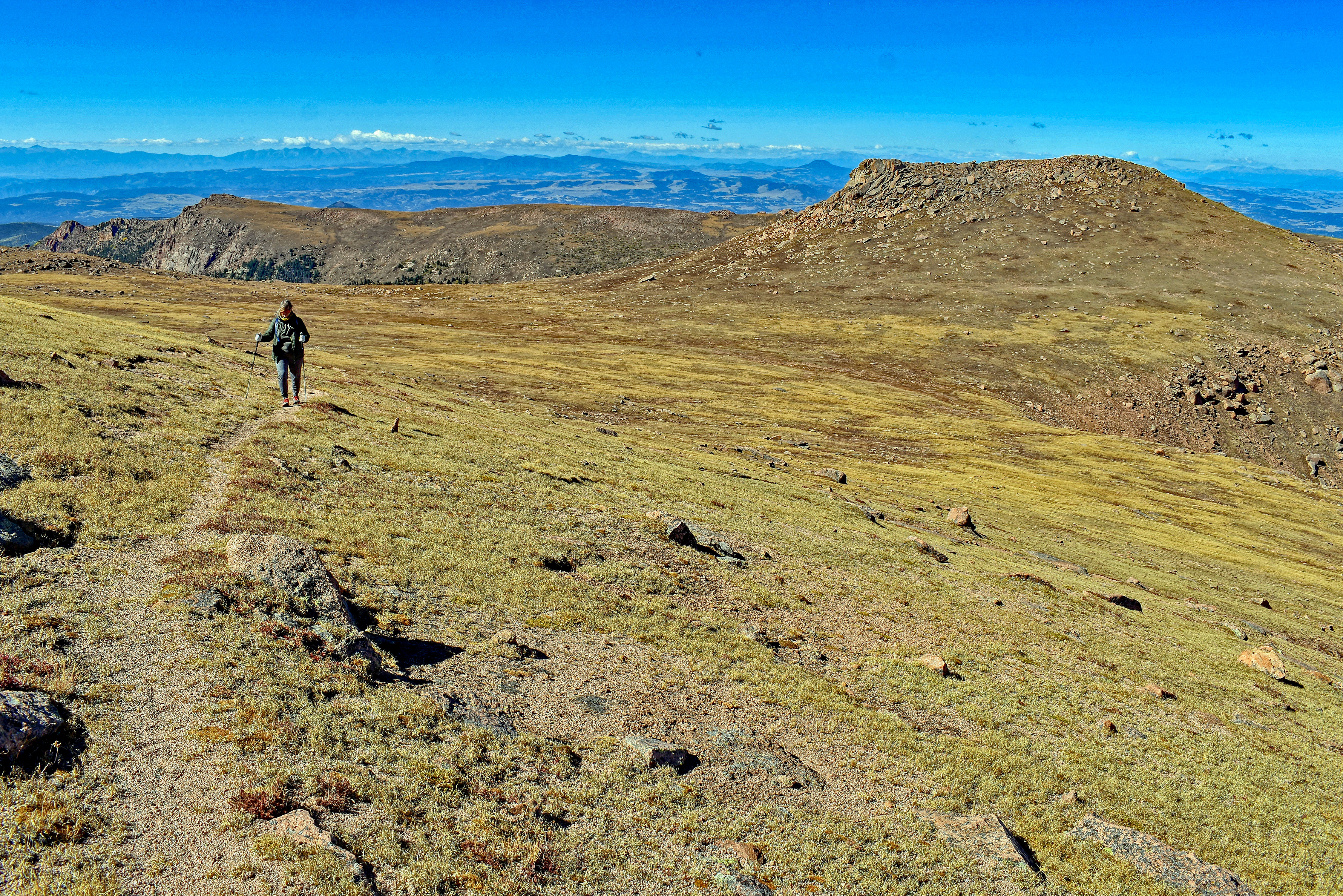
Spencer’s Rest (12,939′) and Bob Ormes Points (13,119′) Unranked
This hike starts on the north side of the Pikes Peak Highway between mile markers 17 and 18. If you’re driving up the road, it’s the pullout on the left just below “Little Pikes Peak.” After you cross the road, look for the faint Gillett Trail. I’d been on the trail a couple of times: in 2005, when I hiked to the summit of Pikes from Gillett, and in 2013, to climb “McReynolds Peak.” Seldom used except by peakbaggers trying to finish all the ranked summits in Teller County (McReynolds), the trail is overgrown but it’s there. If you lose it, step on rocks and slabs to avoid damaging mountain tundra until you locate it again. Spencer’s Rest is west-southwest of the pullout.
Spencer’s Rest is a short easy hike off the Pikes Peak Highway on the west side of Pikes Peak. Photo by Stewart M. Green.
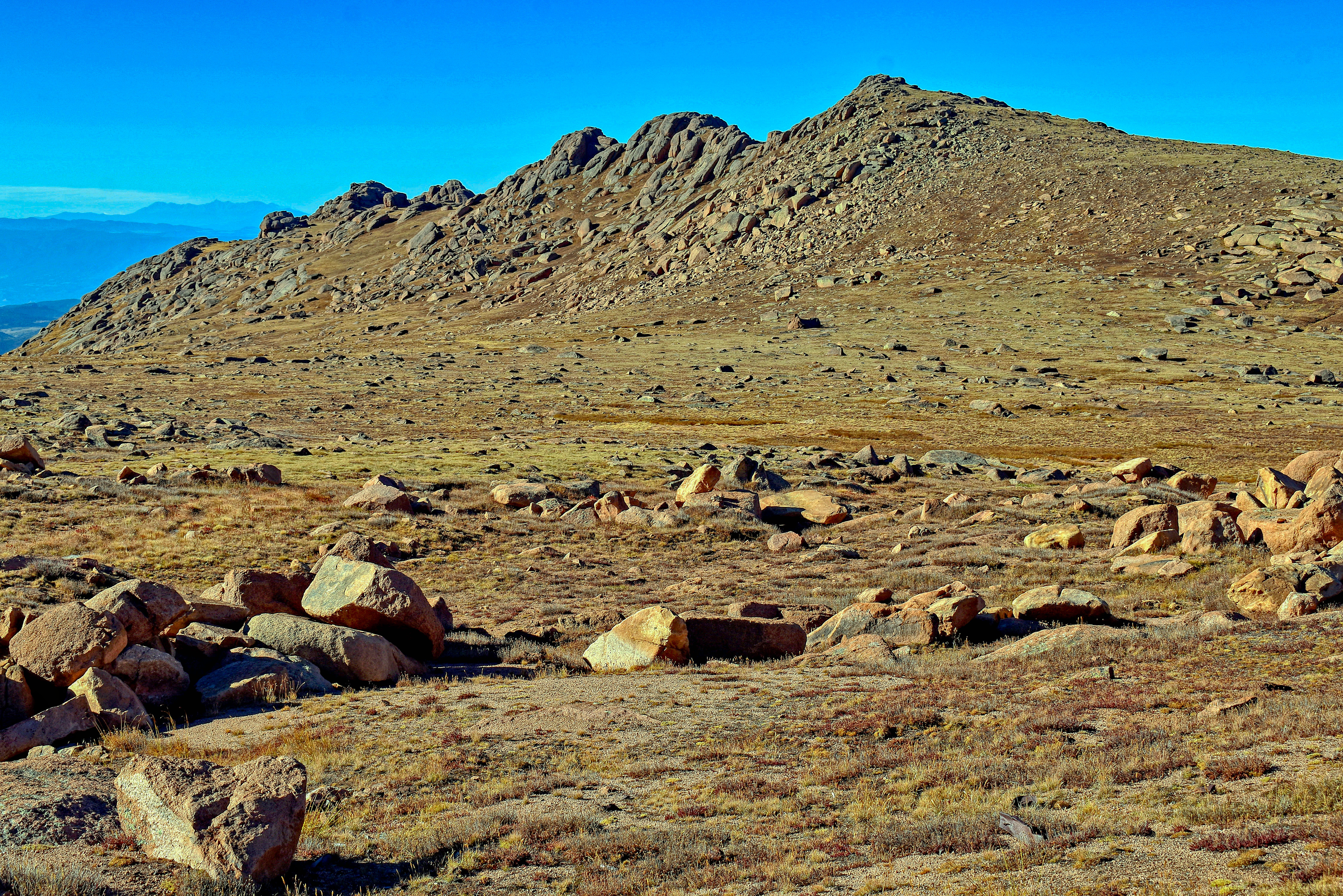
Next, descend the peak and hike east to the northernmost highpoint of a long ridge of summits, Bob Ormes Points. Alternatively, you can start at the southernmost point and hike the ridge to the highest point.
The whole hike is short, less than three miles, and with less than 1,000 feet of elevation gain you can do both Spencer’s Rest and Bob Ormes Points and be back to you car in an hour. You’ll want to linger on the summits, though – the views are stupendous!
Bob Ormes Points are a short hike from Spencer’s Rest. Photo by Stewart M. Green.
“Little Pikes Peak” (13,363′) Unranked
Back at your car, you can either do “Little Pikes Peak,” located near the pullout, or drive to the summit for doughnuts and more views, like I did. On the way back down the highway, park at the same pullout (between mile markers 17 and 18, this time on the right side of the road). “Little Pikes Peak” is the obvious rocky summit west of the pullout. I hadn’t done this hike since 2008 and it hadn’t changed: still short, still steep, and still bouldery on top. Again, avoid the tundra and look for rocks and slabs for your footing.
Little Pikes Peak viewed from the Gillett Trail. Photo by Stewart M. Green.
Next, continue driving down the road for another 1.6 miles to the Devils Playground parking lot on the left side of the road.
“Devils Playground Peak” (13,070′) Unranked
If you’ve ever climbed Pikes Peak from the Crags Trailhead in Divide, you know that the Devils Playground parking lot is where you leave the trail and cross the Pikes Peak Highway for the final 2.6 miles to the summit. County highpointers know it as where to park to get the highpoint of Teller County, “Devils Playground Peak.” This little summit used to be a bit of a scramble, but now there’s a trail. I’ve done it three times – in 2008, 2012, and last week – and for some reason, I failed to take a photo on any of those hikes. The peak is hard to miss – it’s the obvious bump on the west edge of the lot. There’s a trail.
There you have it. Four easy summits and a lovely drive to the top of America’s Mountain. Not a bad day!
Find details to these hikes and many more in Climbing Pikes Peak.
I read the news of the Pikes Peak Cog Railway shutdown with mixed feelings. This is the train that transports people from Manitou Springs, Colorado, to the summit of America’s Mountain, 14,115-foot Pikes Peak. The annual temporary winter closure for routine maintenance has become an extended decommissioning of two to three years while the railway’s owner, the Broadmoor, evaluates options for rebuilding or replacing the train, tracks, and depot. The result may be that it never runs again.
My initial reaction was: this is probably a good thing. Like many Coloradans, I enjoy the outdoors, support the Leave No Trace principles, and believe the best 14ers are those that get the least traffic. That part of me would like to see the railway, the summit house – and the Pikes Peak Highway, for that matter – close for good.
But another part of me was struck with sadness and a bit of sentimentality. Why did the news bother me? Why did I care about the closing of a silly red train that hauls tens of thousands of “outsiders” (you know – sniff! – tourists) to the top of our mountain every year? I had to clear a lot of cobwebs – and “jog the cogs” – from my memory to sort out this strange emotional attachment I felt for the train.
Twenty years ago, I took my two boys for a ride on the cog railway. The nearly nine-mile ride from Manitou Springs through subalpine forest and finally, above tree line, seemed to take forever but the conductor kept us amused with the history of the train and Pikes Peak. He even threw in an occasional quip that caused my kids to roll their eyes. As a mom, it’s always a pleasure to see your kids roll their eyes at something other than you.
Wandering the summit was a thrill. It was our first time over 14,000 feet and my kids (who at that age seemed to relish offsetting my enthusiasm for everything by never being impressed by anything) actually seemed to get a kick out of the views. We drank hot chocolate, gobbled up doughnuts, and purchased a couple of gleaming pressed pennies as souvenirs. It was a good day out.
I never rode that fancy red and white train again, but I did revisit the tracks. In November 2006, during the Zebulon Pike Bicentennial Reenactment hike, my group of eight emerged from the forest to pick up the tracks south of Sachett Mountain at 12,000 feet and follow them to the summit. It was 9 degrees and a light snow was beginning to fall. As eager as I was to finish the three-day trek, I slowed down toward the end to savor those last feet of train tracks, knowing I would probably never walk them again.
A couple of years later, after a January hike to the top of Pikes Peak via the “Crags Route” from Divide, I saw the train again. The summit house was closed that day and the entryway was packed with snow, offering little protection from the biting wind. I pressed my back against a drift and sipped hot cocoa from a thermos, trying to warm my chilled bones, but it was no use. It was just too darned cold up there to enjoy the summit, so I told my hiking partner I needed to head down. Suddenly, a whistle shrieked. My buddy and I looked at each other. Maintenance workers? Today? We continued packing up our backpacks for the long hike down, but then the train appeared – pulled up right in front of us! Hundreds of tourists peered out the windows at the two of us. We must have looked like frozen guards, covered in frost and sitting in the snow at the entry to the summit house. Some workers jumped from the train, cleared a path to the doors, and opened the place up. We filled up on coffee and doughnuts and thanked the tourists who offered to help us “find a way down.” They thought we were lost and had ended up on the top of Pikes Peak by accident! Then we headed down – on foot.
Later that year, in December, I found myself crossing the tracks during a descent of another peak in the nearby Manitou Springs quad. It was December, there was a lot of snow, and my hiking buddy and I assumed the train wasn’t running (how soon we forget!) so we weren’t worried about being run over – or being “caught” as we suspected that walking the tracks probably wasn’t legal.
I guess I never realized how quiet the cog train is. It came around the corner like a wall of red. The train engineer looked as shocked to see us and we were to see him! We leapt from the tracks and into the snow. That was the last time I hiked across the cog tracks.
My last encounter with the cog railway wasn’t on the red and white train, but on Carriage 104, one of the original train cars. In 2016, the cog celebrated its 125th anniversary and visitors were treated to a quarter-mile “push” up the tracks by Steam Engine Number 4, an older version of the train that had been retired in 1958. While I appreciated the history lesson, being pushed – rather than pulled – by an engine is a very different experience. I don’t know if I would have enjoyed a 1950s 9-mile trip that way, being jostled up those tracks!
I’m sure many Coloradans have their own Pikes Peak Cog Railway stories. Trains, peaks, and outdoor adventures are all part of our state history and what made this place what it is today.
Reconciling my railway nostalgia with a desire to protect the peaks is difficult. The balance between sustainability and accessibility is delicate and not always convenient. A few years’ rest from all those visitors would surely do old Pikes Peak some good, but I hope someday the owners of the Pikes Peak Cog Railway find a way to get the train moving again.
This blog first appeared as a column in the March 28, 2018, Woodmen Edition of the Gazette Community News.
Goals are fun to reach, but as they say, it’s the journey that makes them worthwhile. I was reminded of that fact last week when I met with a group of fellow hikers to sign the Colorado County Highpointers Ice Axe.
Signing the Colorado County Highpoint Ice Axe [Photo] Stewart M. Green
Yes, there are people out there who try to get to the top of every county in Colorado. Actually, there are people who do this in every state. Hikers who reach the summits of all 64 Colorado counties are invited to sign a ceremonial ice axe. The tradition was started by Dave Covill and John Mitchler who aren’t just avid highpointers, they literally wrote the book on Colorado county highpoints, “Hiking Colorado’s Summits” (FalconGuides, 1999). The two men share a hobby of getting to the highest points of things: states, counties, countries, mountain ranges, national parks and monuments, major cities – and even, I learned last week – golf courses. Highpointing is a fun challenge that takes you to places you might typically never visit.
Hardcore mountaineers like to poke fun at highpointers because some of our achievements aren’t really all that impressive. For example, reaching the highpoints of certain Colorado counties on the eastern plains demands nothing more than a long drive on dirt roads followed by wandering around cow pastures with a hand level and a GPS – with the landowners’ permission, of course. The metro Denver county highpoints are roadside, and one is paved. But other highpoints are much more challenging. Weld County’s highpoint is located on a bison farm. It’s not a tough hike, but avoiding that large herd of 1,000-pound, curious bison was an experience I’ll never forget.
I started highpointing while I was working on another list, all the Colorado 14,000-foot peaks, or 14ers. There were times when the avalanche danger was too high to safely pursue the big peaks, and so having another list to fall back on gave me an opportunity to get out of the house, hike or climb something, and check off a peak on a list! I ticked off the eastern plains and metro Denver highpoints, which when added to the 14,000-foot highpoint peaks accounted for a majority of summits on the county highpoints list. My quest got a lot more interesting after that, taking me all over the state to places like Clark Peak in the Rawah Wilderness east of Walden, Mount Zirkel in the Mount Zirkel Wilderness near Steamboat Springs, Flat Top Mountain in the Medicine Bow-Routt National Forest, and Hagues Peak in the Mummy Range of Rocky Mountain National Park. To the south, Pueblo County’s Greenhorn Mountain and Las Animas County’s West Spanish Peak, both visible from I-25, gave me an excuse to visit the towns of Rye and La Veta, and the views – well, you’ll just have to go up there yourself. They are stunning.
I finished my county highpoint journey on Vermilion Peak in the San Juan Mountains above Ice Lake Basin near Silverton. It was one of the toughest peaks of the lot and I don’t know why I left it until last, but it was a joy to be up there enjoying the views, knowing I had finally completed a goal started years ago on El Paso County highpoint Pikes Peak. It was a sad experience, too, because it was the last peak on the list. I know that sounds silly, but I didn’t want it to be the last. I wanted more highpoints.
I was the 36th person to sign the axe last week, joined by #37 Doug Hatfield, #38 David Johnson, and #39Mike Offerman. I’m sure many more people will pursue the Colorado County Highpoints list and finish it, too. If you’re one of those people, take a moment up there on those summits. Don’t be in a hurry to come back down. It’s nice up there, and sometimes you don’t realize just how nice until after you’ve done them all.
Summit of Vermilion Peak, September 19, 2015. [Photo] Stewart M. Green
This column first appeared in the September 28, 2016 Woodmen Edition of the Gazette Community News.
My latest book, Climbing Colorado’s Mountains, was edited from the original manuscript and more than 21,000 words had to be cut to fit the book format. Following is the original chapter I wrote about the geology of the mountains.
Rocky red towers of sandstone–remnants of an ancient seabed–frame Pikes Peak (14,110′) above Colorado Springs. [Photo: Stewart M. Green]
Three major provinces comprise Colorado’s topography: the plains or prairies of the east, plateaus of the west, and the mountains—specifically, the Rocky Mountains—that split the state from north to south, between the prairies and plateaus. The Rocky Mountain system is composed of many smaller mountain ranges and subranges, most running north-south, with a few running east-west. The mountains, or peaks, of Colorado are as varied as the forces that created and defined them. Our mountains began their slow development about 1.8 billion years ago, when the shifting of tectonic plates—sections of the earth’s outer crust or lithosphere—movement of molten rock or magma within the Earth’s crust, and volcanic eruptions all served to thrust the landscape of our state upward. At the same time, wind, rain, ice, lava, and rock fall pummeled the terrain, eroding the uplifted earth away to a lower, smoother playing ground. It is these two forces, uplift and erosion, that formed the mountains of Colorado we see and climb today.
Fishers Peak (9,627′) rises up more than 3,500 feet above Trinidad at the edge of the Great Plains near Raton Pass. [Photo: Susan Joy Paul]
Generally speaking, the major ranges of Colorado can trace their origins back to uplift in the form of batholiths and faulted anticlines. Batholiths formed when an igneous intrusion—molten rock that intruded the lithosphere but did not break through to the surface—solidified as a large mass beneath the earth, and was later exposed due to volcanic activity that pushed it up, and by erosion that cleared sediment from the surface. Underground pressure forced softer rock upward into tent-like folds or anticlines, and faults were created as the rock—under tremendous stress—split, and the sections shifted apart. Erupted volcanoes and layers of eroded and erupted rock, or sediments, topped some of the mountain ranges as well, forming newer ranges. Mountain building, or orogeny, is not isolated to Colorado, and in fact the Rocky Mountains extend north into Canada and south into New Mexico, and are part of a larger system known as the North American Cordillera, a subrange of the American Cordillera that stretches from Alaska to South America.
The many types of rocks created by uplift andberosion add to the variety in our peaks. Colorado’s mountains are composed mainly of igneous rocks like basalt, breccia, gabbro, granite, pegmatite, porphyry, and tuff; sedimentary rocks like conglomerate, dolomite, limestone, sandstone, and shale; and metamorphic rocks like gneiss,hornfels, migmatite, schist, and quartzite.
· Igneous rocks are formed by molten rock as it cools and hardens. Magma can rise and push through the surrounding rock, exploding above the surface as fine-grained volcanic rock, or it can solidify below the surface, as coarse-grained plutonic rock. Intrusions of plutonic rock may be exposed over time, as batholiths, dikes and plugs.
· Sedimentary rocks are made up of beds of material that have accumulated through erosion of older rocks, precipitated from water sources above or below the ground, or are the remains of plants and animals. The beds consolidate in layers, and the angle of the layers from the Earth’s surface present various slope and ledge systems, and challenges, for the mountain climber.
· Metamorphic rocksare created when rocks and minerals are subjected to intense heat and pressure, changing the mineral structure and forming a new type of rock. The type of new rock created varies, based on the original matter, the temperature and duration of the heating, and the amount of pressure. Contact metamorphism occurs in rock that’s heated due to proximity with superheated magma or a lava flow. Regional metamorphism is caused by the shifting of tectonic plates, when rock is forced deep into the Earth, and high temperatures and extreme pressure cause the rock to metamorphose.
The Crestone Mountains of the Sangre de Cristo Range form a striking backdrop above Great Sand Dunes National Park and Preserve in southern Colorado. [Photo: Stewart M. Green]
It may seem strange that the mountains of landlocked Colorado consist of such a wide variety of rocks and minerals, until you examine the geologic evolution of our state. The geologic record tells us the Earth’s crust stabilized four and a half billion years ago, and the uplift and erosion that formed Colorado’s landscape occurred within roughly the last 2 billion years. The mountains may not have been here since the beginning of time, but—compared to mere mortals, who appeared on Earth just 2 million years ago, and in Colorado a mere 15,000 years ago—they have been in development for a very, very, very long time. Here’s a brief summary of the development of our peaks:
· 1.8 billion years ago: The area on Earth we know as Colorado was a series of island chains off the coast of the ancient supercontinent of Laurentia. Tectonic plates, sections of the earth’s lithosphere, moved north and drove the islands under Laurentia.
· 1.7 billion years ago: During the Colorado Orogeny, magma beneath the lithosphere interacted with the island rock, forming igneous and metamorphic rock, the basement rock that emerged as the Colorado Province,and which forms the bases of our oldest mountain ranges.
· 1.4 billion years ago: The Berthoud Orogenydefined a period of tectonic plate shifts and batholith surges in Colorado, evidenced by—among others—the St. Vrain (Longs Peak) Batholith, Silver Plume Batholith, and the Mount Evans Batholith in the Front Range, the San Isabel Batholith in the Wet Mountains, and the St. Kevin Batholith in the Sawatch Range.
· 1.1 billion years ago: During the Grenville Orogeny the Pikes Peak Batholith intruded the outer crust of the earth as an irregular, elliptical mound of superheated magma, and cooled a mile or two beneath the surface.
· 1.1 billion to 500 million years ago: Erosion exposed and softened basement rock, forming low, rounded hills throughout the state. Erosion also exposed the surfaces of the intruded batholiths, such as the 1,200-square-mile mass of the Pikes Peak Batholith that now makes up the Tarryall Mountains, Rampart Range, and the Pikes Peak Massif in south-central Colorado.
The Diamond Peaks at Cameron Pass form the southern terminus of the Rawah Range, offering views south to the Nokhu Crags of the Never Summer Range. [Photo: Susan Joy Paul]
· 320 million to 250 million years ago: A slow (very slow) collision between all the land masses formed the supercontinent of Pangaea. The collision created uplift, forcing large masses of metamorphic rock up through layers of limestone and dolomite—sediments of ancient seas—forming faulted anticlines in the basement rock of Colorado. As the rock was being uplifted, it was also being worn away by erosion. The Front Range Uplift in central Colorado and the Uncompahgre Uplift in western Colorado created two northwest-to-southeast trending ranges of about 10,000 feet, Frontrangia and Uncompahgria. These ranges comprised the major mountains of the Ancestral Rocky Mountains. The uplifts caused the complete erosion of surrounding sedimentary rock in some places, and today those areas are marked by an absence of old layers of rock, and an uncomformity exists where newer sedimentary rock lies directly on top of the ancient basement rock. The Great Unconformity refers to a great lapse of time in the physical, geologic history of the land, and is found in areas across Colorado.
· 250 million to 100 million years ago: The Ancestral Rockies eroded away, and their overlying sediment was swept down their slopes and deposited to the east and west in tumbled-down sediment.
· 75 million to 45 million years ago: Plate movement from the west increased, affecting a compression of the earth below, and buckling of the surface. A mountain-building episode of uplift known as the Laramide Orogeny occurred, where the area between what are now the cities of Grand Junction and Denver was shortened by as much as fifty miles, and the Laramide Mountains rose up, defining the areas of the major mountain ranges in today’s Colorado. At the same time, magma rose up in a diagonal line from the southwestern San Juan Mountains northeast to the Front Range. Much of the magma solidified below, forming Colorado’s Mineral Belt: great masses of igneous rock laced with deposits of gold, silver, lead, and zinc. Magma also made its way to the surface, feeding volcanoes. The Colorado River began to form at this time, west of the Laramide Mountains, eventually flowing southwest to carve out the Grand Canyon in Arizona.
· 45 million to 35 million years ago: Uplift slowed but erosion continued along the area of the Laramide Orogeny, and thepeaks were gently reduced to low mountains and rolling hills rising from plains just a few thousand feet above sea level. At the same time, magma intrusion increased, exploding above the surface as volcanoes.
· 35 million to 26 million years ago: Volcanoes rose up in northern Colorado, spewing lava that hardened and was later eroded during periods of uplift, and by wind, water, and gravity. Volcanic activity in the southwest part of the state forced ash into the air which eventually settled, forming a thick layer of tuff throughout the area of the San Juan Mountains. That same activity formed volcanic rock still evident throughout the San Juans, West Elk Mountains, and the Never Summer Range. Igneous intrusion continued, forming more blocks of granite throughout the San Miguel, Sawatch, West Elk, and Elk Mountains, and the Front Range. This period also marks the beginnings of the Rio Grande Rift, when that same volcanic activity that pushed the land upward caused the lithosphere located between the uplifts to rise, thin out, spread apart, and fill with sediment eroded from nearby peaks, and blown in by wind from surrounding mountain passes. In south central Colorado, the Sangre de Cristo Fault and the Alvarado Fault began an active period of thrust, eventually defining the east and west borders of the Sangre de Cristo Range.
The sheer west face of Mount Zirkel (12,180’) is best viewed from Big Agnes Mountain (12,060’) in the Sawtooth Range. [Photo: Susan Joy Paul]
· 26 million years ago: Another tectonic plate shift pulled the land westward, toward the Pacific. Faulting occurred along the Colorado landscape, and the Rio Grande Rift grew, stretching from around Leadville in Colorado, to Chihuahua, Mexico. Great valleys were formed along the rift, such as the northern Arkansas Valley that split the Sawatch and Mosquito mountain ranges, and the San Luis Valley between the San Juan Mountains and Sangre de Cristo Range. Heat generated by plate movement deep within the earth caused a final, great uplift across the land, and much of Colorado was raised by about 6,000 feet.
· 26 million to 2.5 million years ago: Basalt flows capped the Grand Mesa, west.
· 2.5 million years ago: Temperatures dropped, glaciers moved in from the north, and the Ice Age began. Wind-driven ice and snow and grinding glaciers left their mark on 1.4 billion-year-old basement rock, witnessed by chiseled rock face and polished, alpine cirques, such as those on display in the Mummy Range. Subsequent freeze-thaw cycles severed rock from the mountains and cliffs into football-to-crate-sized chunks now seen as talus fields. Ice Age glaciers carved out valleys along the flanks of the Sierra Blanca Range, leaving behind alpine basins and loose moraines. Further pulverizing of the rock created scree fields, and the formation of talus and scree fields continues today.
· 170,000 to 120,000 years ago: A period of glacier activity occurred, witnessed by present-day moraines, polished rock, glacial cirques and enormous, stranded boulders, glacial erratics that were formed or carried by moving slabs of ice.
· 30,000 to 12,000 years ago: Another period of glacial activity continued to mark the land, and high basins were formed, the eventual settings for today’s alpine lakes. Humans first appeared in Colorado during this time.
· 12,000 to 5,000 years ago: Temperatures rose and the glaciers retreated.
· 5,000 years ago to the Present: Colorado’s current “glaciers” and perennial snowfields are not remnants of the Ice Age, but were formed in later years during short periods of cold, including the Little Ice Age that occurred just a few hundred years ago and ended in the late 1800s. Rock glaciers were also created, rocky remnants of ice glaciers seen along mountain slopes, their movement eased by bits of ice formed of precipitation caught and frozen beneath the surface. Rock glaciers are still found in Colorado, such as on Mount Mestas at La Veta Pass in south-central Colorado, and Engineer Mountain at Coal Bank Pass, in the southwest part of the state.
Mountain building did not come to an abrupt halt in the 21st century, and Colorado’s mountains continue to evolve, shaped by forces of nature like uplift, erosion, precipitation, rockslides, mudslides, flashfloods, and changing temperatures; and by human intrusion with mining, road-building, and of course, mountaineering. This creates an ever-changing and unpredictable environment for the Colorado mountaineer, and a demand for vigilance on every outing.
Vermilion Peak (13,894′) tops San Juan county at Ice Lake Basin near Silverton. [Photo: Susan Joy Paul]
Climbing Colorado’s Mountains (October 2015, FalconGuides) features driving directions, route descriptions, maps, photos and GPS waypoints to 100 Colorado mountain adventures.